
Map from Land Surveys in Penobscot County
Zebulon Bradley, “Official Copies of Land Surveys in the County of Penobscot. Prepared under the direction of the Land Agent of Maine in compliance with Resolves of 1887 and 1889.” Penobscot County Registry of Deeds, Bangor.
Background
Before the arrival of white settlers, the Penobscot inhabited lands that spanned the modern-day states of Maine and Massachusetts. They divided their lands into family hunting territories that could support communities of up to 100 people.
Decades of broken treaties and illegal sales reduced the Penobscot land to the islands in the Penobscot River by 1833. Without the miles of forests and waterways that once supported their traditional way of life, many Penobscot turned to farming. Unfortunately, the traditional practice of sharing land did not work for farming, and land disputes arose.
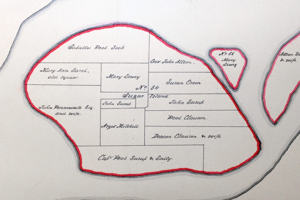
In 1835, the government of Maine appointed a white man named Zebulon Bradley to solve the land disputes. Zebulon divided the Penobscot islands into lots. He then assigned each lot to an individual or family. This kind of land ownership was contrary to Penobscot traditions, so they formed a collective governing body to oversee the management of the islands. To this day, the governing body makes recommendations based on what is best for the land, river, and community, but individuals can decide whether to follow the recommendations on their lot.
About the Document
This map shows how one of the Penobscot islands was divided up into lots granted to individuals and families. Some of the lot owners are women. The map demonstrates that Penobscot women had more rights in their community than white women had in U.S. society. This disparity would become a driving force in the movement to grant married white women the right to own property.
Vocabulary
- Penobscot: An Indigenous tribe that originally inhabited the lands that are now called Massachusetts, Maine, and Quebec. Today, the Penobscot Nation is headquartered in Maine.
Discussion Questions
- Why was this map made? What do the names on the maps indicate?
- Did the government of Maine have the right to settle the Penobscot land disputes? Why or why not?
- Why is it significant that some of the names are women? What does this reveal about the role of women in Penobscot society and culture?
Suggested Activities
- After examining this source, ask students to examine the Married Women’s Property Act and then write a short essay on the following prompt: How did Indigenous attitudes toward women shape U.S. laws about women’s rights?
- For a larger lesson about Indigenous displacement in the 1800s, teach this resource together with the following:
Themes
AMERICAN IDENTITY AND CITIZENSHIP


